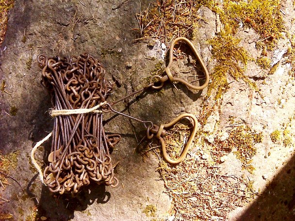
Gunter's Chain
Images courtesy of John Allison, Aberdeenshire and Moray Forest District.
Image of survey chain (Gunter’s 22 yard chain) The chain was divided into 100 links, marked off into groups of 10 by brass tags which simplified intermediate measurement. The first tag from each handle end was single pointed, the second tag double pointed and so on up to the fourth or 40th link four point marker. The end of the 50th link or mid point was usually a plain round tag.
Although the chain was 22 yards long and composed of 100 links, the important point to remember is that the unit of land length measurement was chains much as we use metres today. There were 80 chains to the mile and of key interest to the forester, 10 square chains to the acre. If a rectangular parallel sided compartment was 5.0 chains wide by 20.2 chains long the area was 101.0 sq chains which if divided by 10 gave 10.1 acres. Simple!
Older measurement units fitted in with the chain well as there were 4 poles in one chain, 10 chains in a furlong and 8 furlongs to the mile. (I think that is correct if I remember chanting in primary school correctly!)
Measuring with a chain involved two people, the surveyor or forester and chainman (or second man). When setting out compartments within a forest very often straight lines were used. A large marker or coloured ranging rod would be placed at the distant corner and starting at the near corner the surveyor would take as accurate a bearing with a prismatic compass as he could keeping clear of any iron objects (chain or fences) and note reading down in a survey book.
The chain was pulled out by the chainman in a line directly towards the distant marker. The surveyor holding the rear end of the chain stood next to the first corner marker and would call when the full length was almost out. Chainman would turn, tension the chain carefully and ensuring his hand was in clear sight of the surveyor and under the surveyor’s guidance, push a marker metal pin into the ground at the very end of the tensioned chain and in direct line with the distant marker. After the metal marker pin was inserted, the team moved forward until the surveyor reached the first metal marker pin. Holding the end of the chain against the 1st metal marker pin, he would again ensure correct tension and that the chainman’s hand and second metal pin were in direct line with the distant corner. This procedure was repeated until the distant corner was reached.
Normally ten metal marker pins were used (in surveys with many long stretches - 20 pins) and careful count was kept of them to ensure none were lost. If a straight line was longer that 10 pins (10 chains) the chainman would stay at the last metal marker pin and the surveyor would walk up to him, mark the point and lift the pin, count and hand the 10 pins over to the chain man to complete the survey line.
At the end of the straight line the surveyor would count the number of pins he had lifted or reached and then add on the decimal parts of the last chain length between final metal marker pin and target corner marker; check the number of pins the chainman held to ensure none had been missed or lost; enter the total length measurement in the book; take a careful back bearing to the start point; note it down and check that there was a near exact 180 degree difference from his forward bearing. The whole procedure would then restart for the second side of compartment with the taking of a forward bearing to the third distant marker.
The metal marker pins approximately a foot long made of stiff wire were quite difficult to keep track off and usually pieces of coloured tape or cloth were tied into the little ring at the top. Even still, in thick heather, blaeberry or tall grass and rushes they were often difficult for the following surveyor to spot and frequently there was a bit of a search around until found. Chainman could help mark a location by scraping a line or tramping an area with his foot and the surveyor by counting out their normal number of steps for a chain.
See the attached PDF for more images of 'The Chain'.
Groups: Tools, equipment and clothing